Next month, the Los Angeles County Regional Planning Commission will consider a draft pedestrian plan for four of its unincorporated communities: Lake Los Angeles, Walnut Park, Westmont/West Athens, and Whittier-Los Nietos. The plan, branded as Step by Step L.A. County, is billed as a "policy framework" to encourage residents of unincorporated communities to walk more frequently.
Public health and a need for improved street safety are the primary motivations behind the Step by Step. According to the draft plan, almost 24 percent of adults and 23 percent of children in Los Angeles County are considered obese. In some unincorporated communities, including Westmont/West Athens and Whittier-Los Nietos, those figures are even higher. Additionally, Los Angeles County's roads have become particularly dangerous for those who walk. Data shows that between January 1, 2013 and December 3, 2017, a total of 219 pedestrians were severely injured and 86 were killed while walking in unincorporated communities.
By extending sidewalks, adding new crosswalks, and reconfiguring streets and intersections, the County hopes to make walking a safer option for residents of unincorporated communities, thereby leading to healthier outcomes.
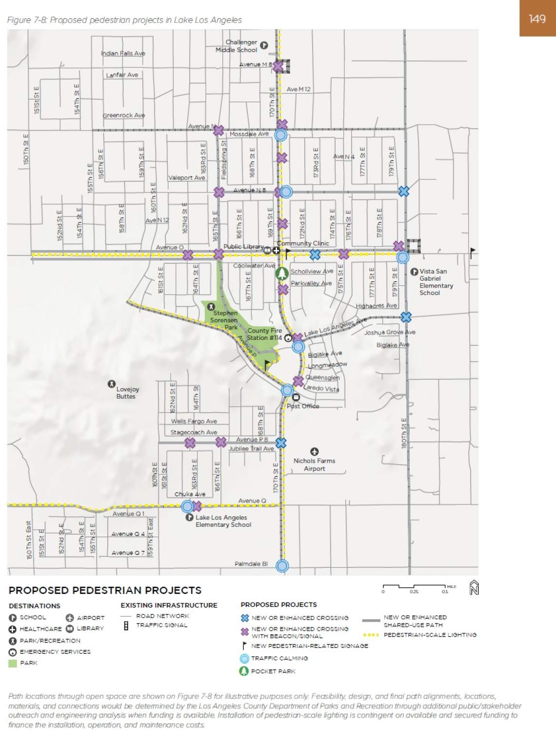
Lake Los Angeles, located north of the Angeles National Forest, is characterized by low-density development. Its residents are largely car-dependent, with less than one percent or residents commuting to work by walking or biking, and only one percent of its residents commuting via transit.
Automobile traffic is heaviest along the community's two major corridors - Avenue O and 170th Street - with posted speed limits of 55 miles per hour, and real-life travel conditions that frequently exceed that number. Avenue O and 170th Street are also two of the handful of roads in Lake Los Angeles with sidewalks, which vary in width and upkeep from place to place.
Currently, pedestrian facilities are limited in Lake Los Angeles. Crosswalks exist at only certain locations, and even at the community's lone signalized intersection - at 170th Street and Avenue O - sidewalks are present at only three corners.
Pedestrian lighting has been historically limited in the Lake Los Angeles area out of a preference to preserve the area's rural character. However, the Step by Step plan notes that this comes at the expense of pedestrian safety - between 2009 and 2016, 13 pedestrian-involved collisions have been recorded along 170th Street East and Avenue O, including two fatalities and nine resulting in a severe injury.
The Step by Step Plan proposes approximately $36 million in pedestrian projects for the Lake Los Angeles area, including:
- new continental crosswalks at intersections and mid-block locations;
- sidewalks and shared use paths in key locations;
- speed feedback signs to slow traffic;
- pedestrian lighting; and
- converting vacant lots to public gathering spaces.
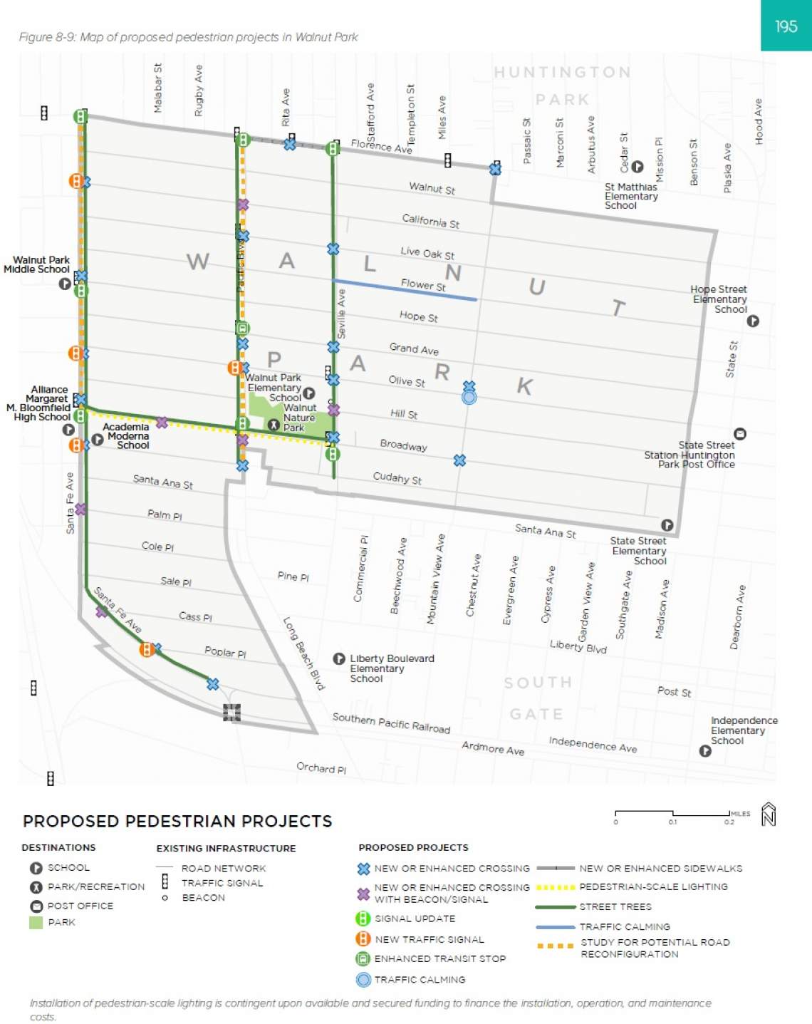
Walnut Park, located between the cities of Huntington Park and South Gate, is a one-square-mile community that is home to approximately 16,000 residents, making it one of the most densely populated parts of Los Angeles County. Owing to its compact dimensions and proximity to numerous transit lines, a higher percentage of Walnut Park residents use public transportation (9.6 percent) than in Los Angeles County as a whole.
The community is crisscrossed by heavily trafficked roads, including Santa Fe Avenue and Pacific Boulevard, where drivers frequently exceed posted speed limits. Due to its urbanized environment, pedestrian facilities are more complete in Walnut Park than in Lake Los Angeles, though there are several areas cited for improvement. Most notably, the community has an inadequate tree canopy, particularly in its southwestern and northwestern corners.
Between 2009 and 2016, Walnut Park saw a total of 58 pedestrian-involved collisions, the bulk of which occurred on Pacific Boulevard and Santa Fe Avenue. Nearly 60 percent of these collisions resulted in a severe injury, and four were fatalities. Nearly half of all pedestrian-involved collisions resulted from a failure of ad river to yield to a pedestrian who had the legal right-of-way.
The array of pedestrian projects slated for Walnut Park are budgeted at approximately $10.6 million. Proposed improvements include:
- potential roadway reconfigurations of Santa Fe and Pacific to enhance walking conditions and add green space;
- continental crosswalks, advanced yield markings, pedestrian-activated warning systems, pedestrian-lead traffic signals, and similar infrastructure;
- new or widened sidewalks and removal or relocation of driveways; and
- new pedestrian-scaled lighting.
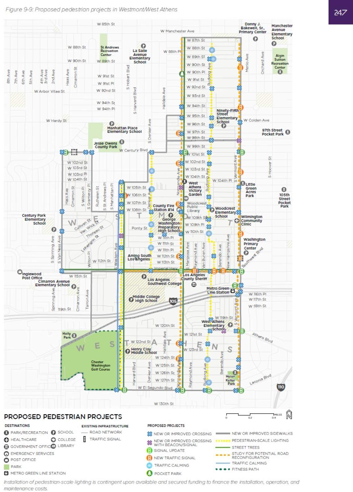
The Westmont/West Athens area is the most populous community involved in the Step by Step plan, with approximately 41,000 residents in an area surrounded by Los Angeles, Inglewood, Hawthorne, and Gardena.
As with the other unincorporated communities mentioned, the bulk of the Westmont/West Athens community is zoned residential, with commercial uses largely restricted to major corridors such as Vermont, Normandie, and Western Avenues, as well as segments of Century and El Segundo Boulevards.
Though Westmont/West Athens commute to work by walking at a lower rate than the County as a whole, the community is known for its high rate of public transit commuters - with 15 percent of Westmont Residents and 11 percent of West Athens taking a train or bus.
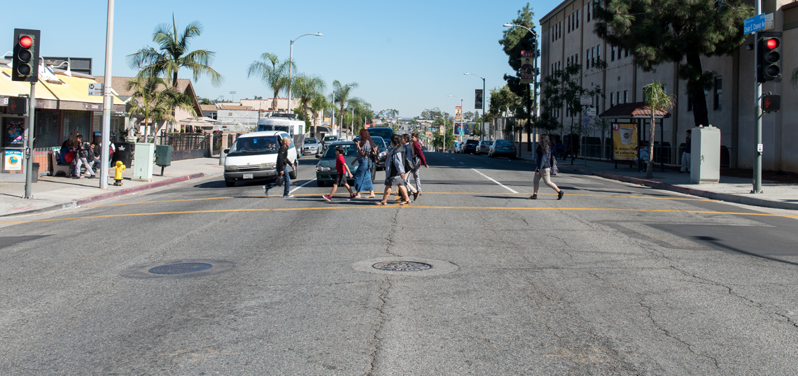
High speeds on the community's primary commercial corridors - including Century, El Segundo, Western, and Vermont - create impediments to walking. The community saw more than 240 pedestrian-involved collisions between 2009 and 2016, more than half of which resulted in severe injuries, and 11 that ended in fatalities. Nearly half of these collisions resulted from pedestrians crossing the street at mid-block locations that lack crosswalks.
The Step by Step Plan puts forth up to $34.6 million in pedestrian projects for the Westmont/West Athens area, including:
- potential roadway configurations to enhance walking conditions and add more green space;
- the addition of continental crosswalks and intersections and mid-block locations, as well as pedestrian-activated warning signals, advance yield markings, and pedestrian-lead traffic signals;
- new or widened sidewalks and multi-use paths; and
- pedestrian-scaled lighting.
Roadway reconfigurations could occur on the primary thoroughfares of Westmont/West Athens, including Vermont, Normandie, and Budlong Avenues - all of which have a history of pedestrian-related collisions and high vehicle speeds. Western specifically could see the restriping of an outside lane to accommodate a marked parking lane and bicycle lanes where feasible.
Vermont's reconfiguration is A reconfiguration of Vermont is contingent upon Metro's future plans for a bus rapid transit line along the corridor - and potentially an extension of the Red Line subway in the more distant future.
Shared-use paths are possible in a center median below transmission lines along 98th Street and along a Southern Pacific Rail Corridor which flanks the 105 Freeway trench.
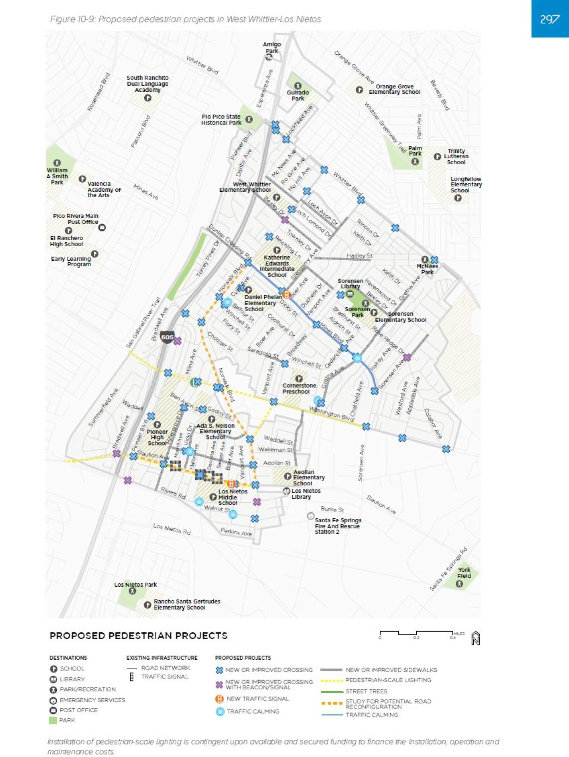
The West Whittier-Los Nietos area is home to 25,540 residents in a 2.5-mile space bordered by the cities of Pico Rivers, Whittier, and Santa Fe Springs.
Approximately 80 percent of the homes in Whittier-Los Nietos were built between the 1940s and 1960s, a time during which sidewalk construction was not required in unincorporated communities. Consequently, most streets were built without sidewalks.
The bulk of West Whittier-Los Nietos is zoned residential, with small segments of commercial zoning located along Washington, Whittier, and Norwalk Boulevards. Owing to this largely suburban built environment, just 1.5 percent of area residents commute to work by walking, and just two percent take public transit. Both of these figures are substantially lower than the countywide average.
Between 2009 and 2015, a total of 59 pedestrian-involved collisions were reported in the West Whittier-Los Nietos area, more than half of which resulted in a severe or visible injury, though there were no fatalities.
Up to $28 million in pedestrian projects are proposed for West Whittier-Los Nietos by the Step by Step plan. Broadly speaking, these projects include:
- roadway configurations to enhance the pedestrian environment;
- improved and new crosswalks;
- widened sidewalks; and
- pedestrian-scaled lighting.
Most facilities would be located along Norwalk Boulevard, Pioneer Boulevard, Washington Boulevard, and Slauson Avenue.
The Step by Step plan, which is being led by the Department of Public Works and the Department of Public Health, is currently in the midst of its environmental review period, with a hearing at the Regional Planning Commission scheduled to occur on April 10.
Implementation of certain projects - particularly roadway realignments - would require further study beyond that of the Step by Step plan.
Funding for the pedestrian plan projects could be provided through a variety of sources, including Los Angeles County's share of Measure M local return dollars, SB 1 revenue through the State of California, and Federal grants.
The pedestrian plans emerge as Los Angeles County considers multiple measures to improving safety for pedestrians and cyclists.
Last month, the Board of Supervisors approved a motion introduced by 1st District Supervisor Hilda Solis which directs the County's Department of Public Works to study the feasibility of adding protective vertical barriers to its existing 46 miles of bike lanes and the 34 additional miles currently in the design phase.
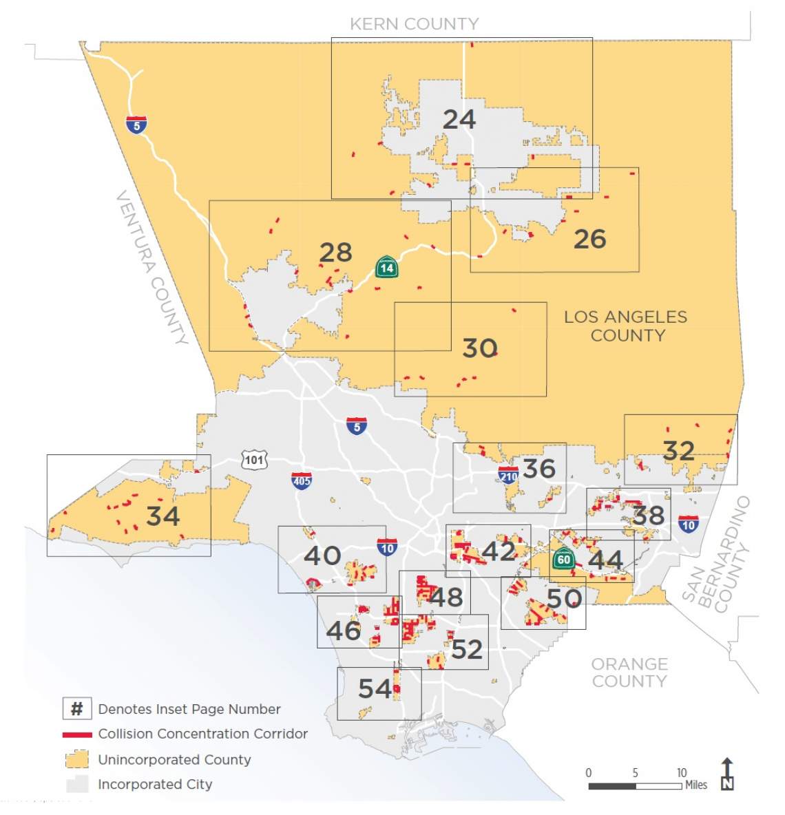
Concurrently, Los Angeles County has debuted its draft Vision Zero Action Plan, with the goal of reducing traffic deaths and severe injuries on roadways in all unincorporated communities. The action plan identifies "collision concentration corridors" in unincorporated areas, and lays out strategies for improving traffic safety on the approximately 3,400 miles of county-controlled roadway. For more information, see Streetsblog's breakdown.