The Atlanta BeltLine is taking a step this week that leaders call crucial to eventually closing the 22-mile loop.
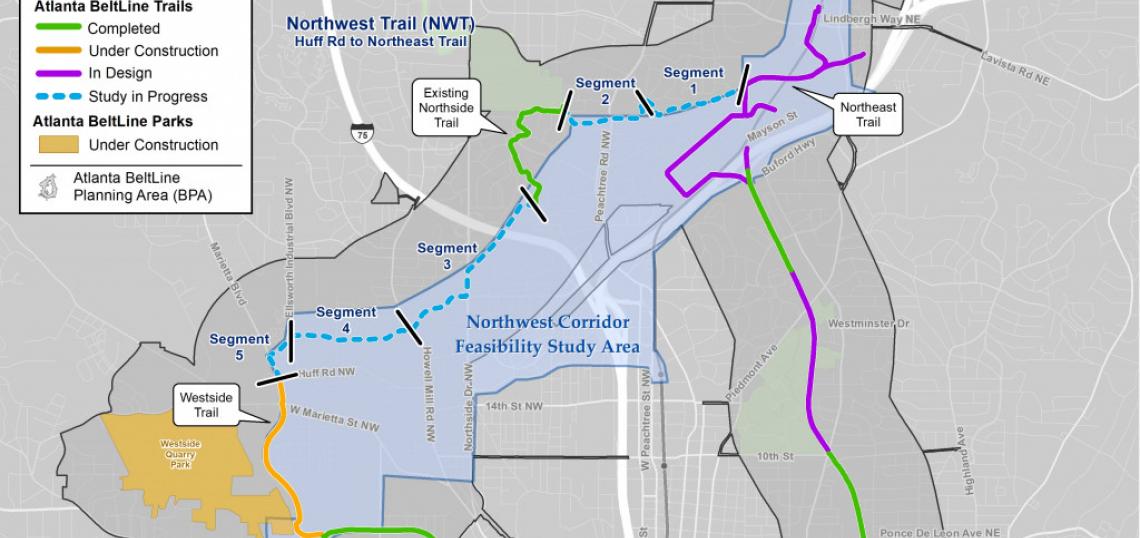
BeltLine heads have officially issued a call for experts to help plan the trail’s northwest segment—a serpentine, 4.4-mile piece from the industrial Westside into southern Buckhead that observers have long called the trickiest portion to build.
On Monday the BeltLine published a Request for Statements of Qualifications for a Northwest Trail feasibility study, paid for with local TAD funding. They’re seeking an engineer consultant to analyze possible trail alignments through a northwest quadrant that would link Huff Road to Peachtree Creek in southern Buckhead.
Active freight rail lines on the northwest portion present a significant hurdle—to the point that building trail and transit near the rail corridor might be impossible. Alternate BeltLine routes could include roads and sidewalks, land next to waterways, or what’s currently private property.
 Broader view of Northwest Trail segment proposals and existing BeltLine. Atlanta BeltLine Inc.
BeltLine leaders are “coordinating with both CSX and Norfolk Southern Railroad and will collaboratively investigate multiple possibilities, to include sections where trail and transit run side-by-side and others where they run separately,” according to an announcement this week.
The northwest corridor is crucial for a truly regional trail next work, with possible links to the Silver Comet Trail and the existing BeltLine Northside Trail along Buckhead’s Tanyard Creek.
The possible new Beltline-area tax—a Special Service District proposed by the Atlanta City Council in January—would cull $128 million needed to create a trail in the city’s northwest corridor, according to the BeltLine. (That would also consume 36 percent of the $350 million the SSD is expected to generate overall.) The estimated cost would cover everything from engineering to real estate purchases and construction.
“Without additional funding from the SSD, or another innovative funding source,” BeltLine reps reiterated this week, “the trail loop will likely not be delivered by 2030.”
Any interested company—or wonky citizen—can review the Request for Statements of Qualifications for the feasibility study and other documents here.
A separate Request for Qualifications is expected to go out this spring to commission a feasibility study for BeltLine transit on the Northwest Trail. “The selected consultants,” BeltLine officials noted, “will work together seamlessly to define both trail and transit alignments.”
…
BELTLINE TALKING POINTS, MISCELLANY
The proposed tax impact—in map form
A new detailed map lends a better idea of exactly which commercial parcels would be required to fork over additional money as part of the BeltLine SSD.
It allows anyone to punch in their business or apartment building address to see if they fall within the half-mile SSD zone on either side of trail segments.
 The SSD map. Atlanta BeltLine Inc.
Following a series of public input meetings, the BeltLine is now awaiting updated tax digest information from the Fulton County Tax Assessor’s Office before moving forward.
“The SSD, if approved by Atlanta City Council, would mean a slight property tax increase up to 2.5 mills for commercial and multifamily property owners within the Atlanta BeltLine Planning Area,” reads the official update this week.
BeltLine officials explain the SSD in depth and make a case for why it’s crucial here.
Northeast Trail debut?
Under construction since late 2019, the first 2/3-mile segment of the Northeast Trail should open sometime in March, weather permitting.
 The Northeast Trail piece in question is pictured in dark yellow. Atlanta BeltLine Inc.
BeltLine spokesperson Jenny Odom tells Urbanize Atlanta no firm date for cutting the ribbon has been set, but a virtual celebration is expected.
 A new Northeast Trail segment near Ansley Mall, looking north from Montgomery Ferry Road.Atlanta BeltLine Inc.
 The same section, prior to construction, in late 2019. Josh Green/Urbanize Atlanta
The Northeast Trail’s first piece—called Segment 2, Phase 1—will stretch from behind Ansley Mall, alongside Ansley Golf Course, to nearly Interstate 85 and the Armour-Ottley District, which is where complications linger with existing rail lines.
For now, the Northeast Trail will be a standard fourteen-feet wide with access points at Ansley Mall's parking lot and a swooping link at Montgomery Ferry Drive.
 How the first Northeast Trail piece will link the Ansley Mall area toward Lindbergh. Atlanta BeltLine Inc.; 2019
BeltLine blinkers
Anyone cruising the Eastside and Westside trails in the evening lately has surely noticed flashing red lights, like short landing strips, down the center of paths.
 Closeup of the new safety measures. Atlanta BeltLine Inc.
No, it’s not a rogue art project, but a series of new solar LED pathway lights meant to boost safety in lower-light situations.
The low-profile lights are being installed at “significant at-grade intersections” to alert users of possible traffic—both cars and people—coming from other directions.
See the Eastside Trail’s intersection with Irwin Street, and the spur leading to PATH’s Stone Mountain Trail in Inman Park, for examples.
• Is the timing right for a new Atlanta BeltLine tax? (Urbanize Atlanta)